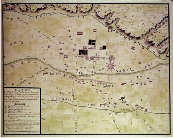
Draftsman José de Urrutia 1767 map of Santa Fe. (Source: santafenewmexican.com)
The New Mexican is republishing columns written by Marc Simmons who wrote a weekly history column for the periodical for more than 35 years. One that caught my attention was the following story in their historical section, “Trail Dust: Report gave glimpse of Santa Fe in 1766.” Simmons’ article tells the story of the Marqués de Rubí’s (a Spanish nobleman) tour of the then frontier of “New Spain.” Rubí was to inspect forts and determine how to improve Spain’s military strategy and defenses against Native American raiders.
Marqués de Rubí’s Santa Fe
Santa Fe was one of the locations that Rubí inspected and he was there for almost one month. Through his reports we can imagine some of what Santa Fe was like in 1766. (Yes, that’s ten years before the original American colonies declared their independence!)
About the capital of Santa Fe, he criticized its poor excuse for a presidio, claiming it was incapable of defending the town. A proper military installation, Lafora noted, might spare New Mexico from another disaster like the 1680 Pueblo Revolt. Almost 20 years would pass, however, before a true walled fort could be constructed north of the Plaza.
When the imposing Rubí expedition rolled into Santa Fe, it must have caused quite a stir among the populace. After all, they had not seen a marqués since don Diego de Vargas had occupied the governorship early in the century. He had been granted the title by the king for his leadership in the reconquest.
Inspector Rubí remained in Santa Fe a full 27 days. It would be a surprise if he was not feted with a grand ball in the Casa Real (Palace of the Governors).
Much of his time was actually spent with then Gov. Tomás Vélez Cachupín, discussing defensive needs of the province. The governor seems to have filled His Lordship’s ear with complaints about the inadequate troops, supplies and money furnished by the royal government.
The total number of men assigned to the presidial garrison was 80, and all had families. Since no barracks or family quarters existed, they lived in private residences.
In line with his instructions, the Marqués de Rubí held an inspection and review of the troop on the Santa Fe Plaza. Since large-scale public amusements of any kind were rare in those days, the citizenry must have turned out in force to view this spectacle.
Capt. Lafora, during the prolonged stay, was taking a census and also drawing up a map of “the layout of the capital,” as he put it. Once he’d completed a rough sketch, he turned it over to the draftsman Urrutia, who rendered it in final form.
The valuable Urrutia map, as it has always been known, shows main roads entering and leaving Santa Fe, acequias, scattered buildings, three churches, the Palace of the Governors and the Plaza. (“Trail Dust: Report gave glimpse of Santa Fe in 1766“)
Read the full article: “Trail Dust: Report gave glimpse of Santa Fe in 1766.”


